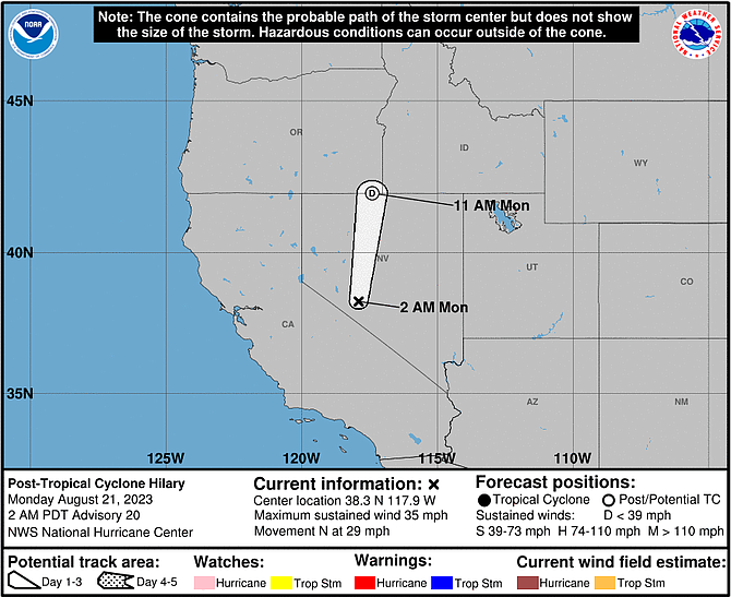
National Hurricane Center forecast for post-Tropical Storm Hilary’s path as of Monday at 2 a.m.
UPDATE, Monday, 6:50 a.m.
Carson City remains under a flood watch through Monday, the National Weather Service said in a statement posted at weather.gov.
“Abundant cloud cover and rainfall will keep afternoon high temperatures 10 to 20 degrees below normal through Tuesday, with Monday likely being the coolest day,” the NWS statement said.
FORECAST
MONDAY
Rain likely before 8 a.m., then a chance of showers and thunderstorms after 2 p.m. Some of the storms could produce heavy rain. Partly sunny, with a high near 74. Southwest wind 5 to 15 mph. Chance of precipitation is 60%.
MONDAY NIGHT
A 50 percent chance of showers and thunderstorms. Some of the storms could produce heavy rain. Mostly cloudy, with a low around 52. West wind 10 to 15 mph becoming light and variable after midnight.
TUESDAY
A chance of showers, with thunderstorms also possible after 11 a.m. Mostly sunny, with a high near 75. Light south wind becoming southwest 5 to 10 mph in the afternoon. Chance of precipitation is 30%.
TUESDAY NIGHT
Mostly clear, with a low around 53. West wind 5 to 10 mph becoming light in the evening.
Here's a sprinkling 🌧 of preliminary rain reports over the past 24 hours. Widespread rain is pushing northward this morning with many areas clearing out around sunrise. Plan on thunderstorms and showers developing this afternoon. ⛈
Image: CNRFC https://t.co/QPtR5FvbCL pic.twitter.com/c5CnXD3jLf
UPDATE, Sunday, 7:30 a.m.
The National Weather Service has issued a flood watch for Carson City.
The watch begins at noon Sunday and continues through late Monday, the NWS said in a statement at weather.gov.
Widespread rains, cooler conditions and an increased risk of flooding are the result of Hurricane Hilary.
“Hilary in the eastern Pacific is forecast to make landfall (Sunday) near the northwestern portion of Baja California,” the NWS said. “While this system will rapidly weaken by the time it arrives in Nevada, significant amounts of moisture will bring periods of heavy rainfall to the region (Sunday) afternoon through Monday. The greatest threat for flooding is across the Basin & Range and the eastern Sierra. However, isolated flooding cannot be ruled out elsewhere across western Nevada and northeast California.
“Abundant cloud cover and rainfall will keep afternoon high temperatures 10 to 20 degrees below normal today through Tuesday, with Monday likely being the coolest day.”
FORECAST
Sunday night
Rain and thunderstorms. Low around 56. East wind 5 to 10 mph becoming northwest after midnight. Chance of precipitation is 90%. New rainfall amounts between a quarter and half of an inch possible.
Monday
Rain likely, with thunderstorms also possible after 11 a.m. Mostly cloudy, with a high near 73. Southwest wind 10 to 15 mph, with gusts as high as 25 mph. Chance of precipitation is 60%.
Monday night
Showers likely and possibly a thunderstorm before 11 p.m., then a slight chance of showers and thunderstorms after 11 p.m. Mostly cloudy, with a low around 53. West wind 10 to 15 mph becoming light southwest in the evening. Winds could gust as high as 25 mph. Chance of precipitation is 60%.
Tuesday
A 40 percent chance of showers and thunderstorms. Partly sunny, with a high near 75. Light and variable wind becoming southwest 5 to 10 mph in the afternoon.
Tuesday night
Mostly clear, with a low around 53. West wind 5 to 10 mph becoming light after midnight.
Wednesday
Sunny, with a high near 81.
UPDATE, Saturday 6:45 a.m.
The National Weather Service said in a statement Saturday morning that showers and thunderstorms will develop Saturday afternoon and evening in Carson City. These storms will be capable of gusts in excess of 45 mph, localized heavy rainfall and small hail.
“Major Hurricane Hilary in the eastern Pacific is forecast to make landfall Sunday along northern Baja of California or extreme southern coastal California,” the release continued. “While this system will rapidly weaken into a remnant low by the time it reaches Nevada, significant amounts of moisture will bring periods of heavy rainfall to the region Sunday afternoon through Monday. The greatest threat for flooding is across the Basin & Range and the eastern Sierra. However, isolated flooding cannot be ruled out elsewhere across western Nevada and northeast California.”
INITIAL STORY
Thunderstorms and rain showers are expected to the Carson City region through the weekend due to moisture rotating across California into the Sierra and later from remnants of Hurricane Hilary pushing up from the south.
“Daily showers and thunderstorms are anticipated into the weekend with localized flash flooding possible,” the National Weather Service said Friday. “A significant influx of tropical moisture from Hurricane Hilary will promote widespread showers and storms Saturday night through Tuesday morning, increasing flooding potential, especially for areas south of U.S. 50.”
A flood watch is in effect from Sunday afternoon to late Monday night for Mono County in California and Mineral and southern Lyon counties in Nevada. A flood watch for the Las Vegas area is in effect from Saturday morning to Monday afternoon.
Parts of western Nevada could see significant rainfall over the weekend.
“Remnant tropical moisture, from what is currently Hurricane Hilary, will surge into the southwest U.S. Sunday through Tuesday,” said the NWS. “How this interacts with a trough off the west coast will have varying implications on the forecast for the eastern Sierra and western Nevada. Keep in mind, this will not be a hurricane when it makes landfall.”
With showers, temperatures will drop to the 70s — 10 to 20 degrees below normal.
“Much of the region will receive at least a half inch of rain over the multi-day period,” said the NWS. “The best chances for higher liquid totals will be south of U.S. 50, where there is a 30 to 50 percent chance for at least 2 inches of rainfall.”
The NWS advised there is a level of uncertainty in the forecasts because “changes in the track of the hurricane remnants will bring differing impacts.”
Carson City Forecast from the NWS:
Sunday
A chance of rain before 2 p.m., then a slight chance of showers and thunderstorms 2-5 p.m., then showers likely and possibly a thunderstorm after 5 p.m. Cloudy, with a high near 71. Southeast wind 5 to 10 mph becoming northeast in the morning. Chance of precipitation is 60%.
Sunday night
Showers likely and possibly a thunderstorm before 8 p.m., then rain 8-11 p.m, then showers and possibly a thunderstorm after 11 p.m. Low around 56. Northeast wind 5 to 10 mph becoming northwest after midnight. Chance of precipitation is 80%. New rainfall amounts between a quarter and half of an inch possible.
Monday
Rain before 11 a.m., then showers likely and possibly a thunderstorm after 11 a.m. High near 73. Southwest wind 5 to 10 mph. Chance of precipitation is 80%.
Monday night
A 50 percent chance of showers and thunderstorms before 11 pm. Partly cloudy, with a low around 52. West wind 10 to 15 mph becoming light southwest in the evening.
Tuesday
A slight chance of showers, then a chance of showers and thunderstorms after 11 a.m. Mostly sunny, with a high near 76. Chance of precipitation is 30%.
Tuesday night
Mostly clear, with a low around 54.
Wednesday
Mostly sunny, with a high near 80.
Wednesday night
Partly cloudy, with a low around 55.
Thursday
Sunny, with a high near 81.
LYON COUNTY SANDBAG LOCATIONS:
Sandbag Locations are listed below, must bring your own shovel ‼️
• Mound House Fire Station – 56 Red Rock Rd., Mound House, NV 89706
• Silver City Community Center - 385 High St., Silver City, NV 89428
• Fire Station #39 - 460 Dayton Valley Rd., Dayton, NV 89403
• Fire Station #35 - 231 Corral Dr., Dayton, NV 89403
• Stagecoach Community Center - 8105 US-50, Stagecoach, NV 89429
• Silver Springs JPO Office - 1075 Pyramid Ave., Silver Springs, NV 89429

Comments
Use the comment form below to begin a discussion about this content.
Sign in to comment